Scalebar and Coordinates
When the Parcel Viewer loads, the Scalebar and Coordinates are automatically enabled at the lower left corner of the Parcel Viewer.
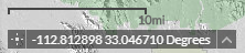
Scalebar
The scale value is based on how far away from the Earth's surface you are.
Coordinates
The coordinates displayed are default of WGS 1984 Web Mercator Auxiliary Sphere.
By clicking the up arrow on the right, there is the option to switch between viewing Decimal Degrees and Degrees Minutes Seconds (DMS). 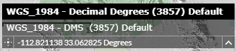
 Enables the clicking map function to get exact coordinates.
- First click the button pictured above to active it. You will notice the coordinates stop updating with the movement of the mouse, the icon will turn teal, and it will say 'Click the map to get coordinates'.
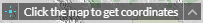
- Next click the location on the map you want the coordinates of. The coordinates on the bottom left will update to show the exact location in either Decimal Degrees or DMS depending on which was chosen.