REST Endpoints
You can access the REST endpoints of the feature layers through the Layer List. Click the ellipses next to a layer and select Description.
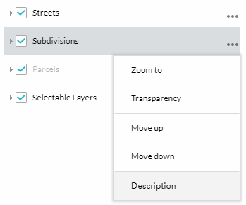
From here you can view the service in:
- ArcGIS Javascript map viewer
- ArcGIS Online map viewer
- Google Earth (.kmz)
- ArcMap (.lyr)
- ArcGIS Explorer (.nmf)
How Can I Use These?
These services can be used to view information about parcels, subdivisions, sections, mapids, etc. exactly how they appear on the parcel viewer. To use these services with ArcGIS Desktop follow ESRI's instructions at http://desktop.arcgis.com/en/desktop/latest/map/web-maps-and-services/about-using-arcgis-services-in-arcmap.htm.
For more information on ArcGIS REST API and how to use it, visit ESRI's resource center at: http://resources.arcgis.com/en/help/arcgis-rest-api.