Architecture
New Parcel Viewer Application
This new parcel viewer Version 3 is served up by ArcGIS 10.9.1 using JavaScript meaning there isn't a plugin to download like there was in the Silverlight application version 2.0. This makes it easier for users to utilize the application on any modern browser whether it be on a desktop PC, tablet or mobile device. It was built using ESRI's Web AppBuilder Developer Edition and then customized using DOJO, Javscript, HTML/CSS, JSON, etc to get the right look and feel.


Cached and Dynamic Services
To allow for both speed and functionality, the Parcel Viewer uses both dynamic and cached services. Dynamic map services perform slower than cached but allow for the ability to have tabular data and geometry that are both searchable and selectable (an example being the Selectable Layers). The cached services perform much faster since tiles of images are grabbed to display when requested by the parcel viewer. As you zoom in closer to the ground the more tiles the cache created (an example being the Assessor Basemap). The downside is that cached services don't have any tabular data behind them so they are not searchable or selectable. Go to REST Endpoints for information on how to view our services.
For more information on ArcGIS REST API and how to use it, visit ESRI's resource center at: http://resources.arcgis.com/en/help/arcgis-rest-api.
Load-Balanced
The public-facing application is load-balanced across multiple servers. The load-balancer's purpose is to take all of the incoming traffic and distribute the load across multiple servers. This helps prevent a single server from being hit with too much traffic and also allows other servers to take the traffic if one or more go down.
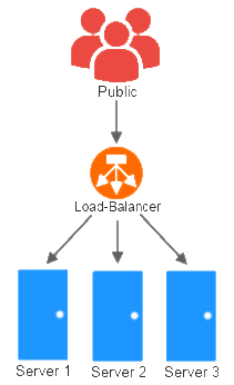
Example of a load-balanced infrastructure